Lab 5: Data Processing 2
2/16/22
Here is the information from my Attribute Table:
(You will need an ODF opener though; this file was originally a DBF.)
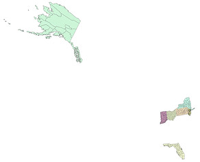
Maps of states I have been to (not including states I have only been to the airport in):
Definitions for this lab:
.DBF/Dbase File: A DBF file is a database file used by dBASE, a database management system application. DBF stands for Database File. DBFs have a relatively straightforward file structure. For this lab I merged the information in my DBF with the Attribute Table in ArcGIS Desktop. Wix.com does not accept DBFs, hence the ODF above instead.
Select by Attributes: Go to "selection" and then "select by attributes" in ArcGIS Desktop and using the given buttons on the screen push and/or drop down the buttons so they are in the bottom (query) field. It is important you use the onscreen buttons because the characters it uses are not the exact same as what you can push on your keyboard. You can select what attributes you want from a layer and then export or create a separate layer from the isolated attributes.
Query: It is selecting certain criteria and then only the result(s) that match the criteria are displayed or highlighted. This is often used to select attributes. In Select by Attributes the query clause you follow is "Select * From <Layer or dataset> Where."
Fields (in a Table): The fields are on the top row of an Attribute Table (columns). You can hide the various fields by going to the layer's properties and going to "fields" and checking the ones you want to appear and unchecking the ones you don't. This is an important and common way of combining outside data files to a layer's Attribute Table. For this lab I used the field "FIPS" as both my DBF had that field and so did the existing Attribute Table.
Records (in a Table): Records are rows which are a part of the Attribute Table. You can select them and search them. By selecting a row it highlights the corresponding area on the map. A record consists of attribute features.
Attributes: The information about geographic features. This is linked to a geographic feature by a unique identifier. This information can be found in an Attribute Table.
Relational Database: It is a database that stores related data and establishes a relationship between data points. You can query a relational database.
Join Function: It is used to add more fields and attributes to the Attribute Table. This can be done by using a field common to both datasets. For this lab that was "FIPS."
Monitor Fire: You did something really wrong and the monitor is unhappy, so unhappy it catches on fire. Follow proper fire safety procedures to appropriately deal with it. On a side note ArcGIS can help monitor real-time emergencies.
Calculate / Field Calculator: It is accessed by going through the Attribute Table. You can perform calculations using this feature. To calculate the percent change in county population you use variations of the formula ( ( ( [Y1910] - [Y1900] ) / [Y1900] ) * 100 ); this calculates the percent change from 1910 to 1900. You have to use the given onscreen buttons (similar to "select by attributes") otherwise it will not work.
Problems in this lab:
The first time I joined my data all the joined fields read as "<null>." It turns out I selected the wrong FIPS to join by. I chose the county FIPS not the state and county combined FIPS. In addition, I played around with the map projection and messed something up so bad I corrupted the whole shapefile to the point I got an error message that it could not display on the map. I couldn't fix it. So I had to create my shapefile again; it wasn't that bad though.